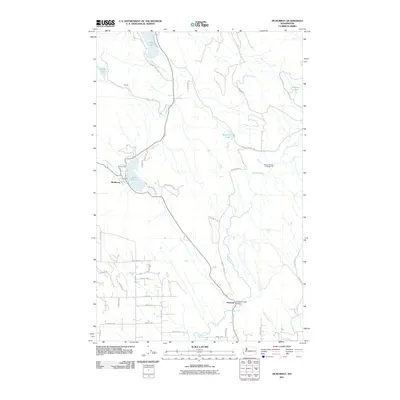
2011 Map of McMurray
USGS Topo · Published 2011About this map
McMurray serves as a central hub on this 2011 survey, situated along the shores of Lake McMurray. The landscape is defined by its complex hydrography, where Pilchuck Creek winds through the southern terrain near the settlement of Pilchuck. To the north, the waters of Big Lake and Nookachamps Creek indicate a region shaped by glacial drainage and timber-friendly geography. A network of rural routes, including Finn Settlement Rd and Peter Burns Rd, connects scattered residences and small settlements like Ehrlich. The presence of the Pilchuck Bridge Campground and isolated water bodies such as Summer Lake and Seabury Pond highlight a shift toward recreational land use in these wooded Skagit County foothills, while the grid of numbered streets to the south suggests the expanding influence of nearby rural residential development.
Find a feature on this map
44 named features on this map. Tap any name to fly to it.
Don’t see what you’re looking for? This feature index may not catch every label — zoom into the map to look around manually.
Map Details
Editions of this 2011 McMurray Map
This is the sole edition of this map. No revisions or reprints were ever made.
Other maps of this area

1911 · Mount Vernon
USGS Topo · 1:125,000

1940 · Mt Vernon
USGS Topo · 1:62,500

1941 · Marysville
USGS Topo · 1:62,500

1943 · Marysville
USGS Topo · 1:62,500

1943 · Mt Vernon
USGS Topo · 1:62,500

1943 · Stanwood
USGS Topo · 1:62,500

1944 · Clear Lake
USGS Topo · 1:62,500

1956 · Arlington West
USGS Topo · 1:24,000

1956 · Arlington East
USGS Topo · 1:24,000
1956 · Stanwood
USGS Topo · 1:24,000