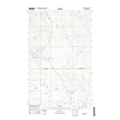
2014 Map of McMurray
USGS Topo · Published 2014About this map
Big Lake and Lake McMurray anchor this corridor of the Pacific Northwest, where the boundary between Skagit Co and Snohomish Co bisects the landscape. The settlement of McMurray sits at the northern tip of its namesake lake, serving as a focal point along the Wa-9 highway route. To the south, the community of Bryant and the small station at Pilchuck reflect the rural development patterns of the early 21st century, defined by a mix of agricultural operations like S and S Farms and recreation-oriented sites such as the Pilchuck Bridge Campground.
Find a feature on this map
53 named features on this map. Tap any name to fly to it.
Don’t see what you’re looking for? This feature index may not catch every label — zoom into the map to look around manually.
Map Details
Editions of this 2014 McMurray Map
This is the sole edition of this map. No revisions or reprints were ever made.
Other maps of this area

1911 · Mount Vernon
USGS Topo · 1:125,000

1940 · Mt Vernon
USGS Topo · 1:62,500

1941 · Marysville
USGS Topo · 1:62,500

1943 · Marysville
USGS Topo · 1:62,500

1943 · Mt Vernon
USGS Topo · 1:62,500

1943 · Stanwood
USGS Topo · 1:62,500

1944 · Clear Lake
USGS Topo · 1:62,500

1956 · Arlington West
USGS Topo · 1:24,000

1956 · Arlington East
USGS Topo · 1:24,000
1956 · Stanwood
USGS Topo · 1:24,000