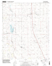
1996 Map of McNary
USGS Topo · Published 2003About this map
The settlement of Mc Neal serves as a central hub in this high-desert landscape of Cochise County, defined by a distinct grid of section lines and water management features. The drainage of Whitewater Draw winds through the western portion of the area, while Leslie Creek cuts across the southeastern corner, reflecting the critical role of water courses in this arid terrain. Extensive infrastructure supports the local community and ranching operations, including several Gravel Pits, a Substation, and a Radio Facility with an associated Tower. Transportation and utility networks are prominent throughout the quadrangle, notably an Airport, a dedicated Landing Strip, and a long Pipeline that traverses the valley floor. Researchers will find a localized Cemetery near the town center, while numerous wells and Water Tanks are scattered across the map, illustrating the systematic development of the region's groundwater resources for agricultural or residential use.
Find a feature on this map
13 named features on this map. Tap any name to fly to it.
Don’t see what you’re looking for? This feature index may not catch every label — zoom into the map to look around manually.
Map Details
Editions of this 1996 McNary Map
This is the sole edition of this map. No revisions or reprints were ever made.
Other maps of this area

1886 · St Johns
USGS Topo · 1:250,000

1892 · St Johns
USGS Topo · 1:250,000

1954 · Clifton
USGS Topo · 1:250,000

1954 · Saint Johns
USGS Topo · 1:250,000

1957 · Clifton
USGS Topo · 1:250,000

1957 · Saint Johns
USGS Topo · 1:250,000

1958 · Clifton
USGS Topo · 1:250,000

1958 · Saint Johns
USGS Topo · 1:250,000

1961 · McNary
USGS Topo · 1:62,500

1962 · Clifton
USGS Topo · 1:250,000