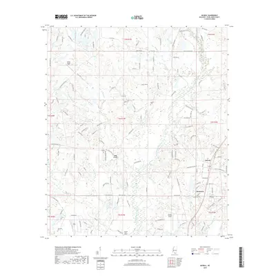
2018 Map of McNeill
USGS Topo · Published 2018About this map
The community of McNeill and the nearby settlement of Hawthorne anchor this portion of Pearl River County, defined by the winding course of West Hobolochitto Creek and its many tributaries. The landscape is a mix of lowland brakes and creek bottoms, including Henry Brake and Riley Brake, interspersed with small aviation hubs like Hooper-Skylark Field and Greener Pastures Airpark. Genealogists will find several family-named burial grounds throughout the area, such as Holleman Cem and Smith Cem, which speak to the rural heritage of the region. Transportation is dominated by the NS railroad corridor passing through the heart of the settlements, paralleling a network of local roads that lead to landmarks like Sones Chapel and the distinctively named Rabbit Hollow. The map captures the interface between the drainage basins of Mill Creek and Price Cr as they navigate the varying elevations of the piney woods.
Find a feature on this map
142 named features on this map. Tap any name to fly to it.
Don’t see what you’re looking for? This feature index may not catch every label — zoom into the map to look around manually.
Map Details
Editions of this 2018 McNeill Map
This is the sole edition of this map. No revisions or reprints were ever made.
Other maps of this area

1942 · Walkiah Bluff
USGS Topo · 1:31,680

1942 · Pools Bluff
USGS Topo · 1:31,680

1949 · Bogalusa East
USGS Topo · 1:31,680

1953 · Mobile
USGS Topo · 1:250,000

1957 · Mobile
USGS Topo · 1:250,000

1958 · Picayune
USGS Topo · 1:62,500

1959 · Bogalusa
USGS Topo · 1:62,500

1959 · Poplarville
USGS Topo · 1:62,500

1960 · Mobile
USGS Topo · 1:250,000
1961 · Sun
USGS Topo · 1:62,500