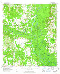
1961 Map of Sun
USGS Topo · Published 1963About this map
The Bogue Chitto River winds through the heart of this landscape, its complex network of oxbows and secondary channels like Dead River and Crooked Bayou defining the border between Louisiana and Mississippi. The Gulf Mobile and Ohio railroad corridor provides a north-south transit spine, connecting small settlements like Rio, Sun, and Talisheek. In the lowlands, the extensive Talisheek Swamp and Talisheek Bay dominate the southern reach, revealing a terrain shaped by heavy drainage and seasonal water flow. Genealogists will find a wealth of family-named landmarks including Magee Cem, Galloway Cem, and Lavinghouse Cem. The map also documents mid-century infrastructure along the river, notably the mechanical footprint of Lock No 2 and Lock No 3, which managed the waterway as it transitioned toward the Pearl River basin.
Find a feature on this map
142 named features on this map. Tap any name to fly to it.
Don’t see what you’re looking for? This feature index may not catch every label — zoom into the map to look around manually.
Map Details
Editions of this 1961 Sun Map
3 editions found
Other maps of this area

1914 · Nicholson
USGS Topo · 1:62,500

1921 · Nicholson
USGS Topo · 1:62,500

1935 · Slidell
USGS Topo · 1:62,500

1935 · Covington
USGS Topo · 1:62,500

1939 · Slidell
USGS Topo · 1:62,500

1939 · Zona
USGS Topo · 1:31,680

1939 · Covington
USGS Topo · 1:62,500

1941 · Honey Island
USGS Topo · 1:31,680

1942 · Waldheim
USGS Topo · 1:31,680

1942 · Thigpen
USGS Topo · 1:31,680