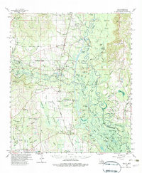
1961 Map of Sun
USGS Topo · Published 1983About this map
The Gulf Mobile And Ohio railroad anchors the local geography of this Southeast Louisiana region, cutting a straight path through the piney woods and wetlands of St. Tammany and Washington Parishes. Near the town of Sun, the Old CHITTO River meanders toward the Pearl River, creating a landscape of sloughs and bottomlands like Devils Swamp. The map reveals a dispersed settlement pattern typical of the mid-20th century, where crossroads communities like Bush and Talisheek served as local hubs.
Find a feature on this map
147 named features on this map. Tap any name to fly to it.
Don’t see what you’re looking for? This feature index may not catch every label — zoom into the map to look around manually.
Map Details
Editions of this 1961 Sun Map
3 editions found
Other maps of this area

1914 · Nicholson
USGS Topo · 1:62,500

1921 · Nicholson
USGS Topo · 1:62,500

1935 · Slidell
USGS Topo · 1:62,500

1935 · Covington
USGS Topo · 1:62,500

1939 · Slidell
USGS Topo · 1:62,500

1939 · Zona
USGS Topo · 1:31,680

1939 · Covington
USGS Topo · 1:62,500

1941 · Honey Island
USGS Topo · 1:31,680

1942 · Waldheim
USGS Topo · 1:31,680

1942 · Thigpen
USGS Topo · 1:31,680