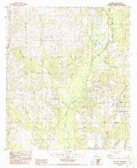
1986 Map of McNeill
USGS Topo · Published 1986About this map
McNeill serves as the primary hub of this Pearl River County landscape, positioned along the rail corridor in the mid-1980s. The area is defined by the winding course of West Hobolochitto Creek and its many tributaries, including Price Creek and Mill Creek, which drain a topography of low ridges and swampy depressions like Riley Brake and Brake. A significant portion of the eastern terrain is dedicated to the Mississippi Agricultural and Forestry Experiment Station, indicating the region's longstanding focus on land management and forestry research. Smaller settlements and named locales like Hawthorne and Marsen are scattered near the southern boundary, while a Lookout Tower stands as a sentinel over the timberlands. Genealogists may find interest in the scattered Cem locations and family-named water features like Rowland Branch and Kennedy Creek that mark the rural sections of the quadrangle.
Find a feature on this map
28 named features on this map. Tap any name to fly to it.
Don’t see what you’re looking for? This feature index may not catch every label — zoom into the map to look around manually.
Map Details
Editions of this 1986 McNeill Map
This is the sole edition of this map. No revisions or reprints were ever made.
Other maps of this area

1942 · Walkiah Bluff
USGS Topo · 1:31,680

1942 · Pools Bluff
USGS Topo · 1:31,680

1949 · Bogalusa East
USGS Topo · 1:31,680

1953 · Mobile
USGS Topo · 1:250,000

1957 · Mobile
USGS Topo · 1:250,000

1958 · Picayune
USGS Topo · 1:62,500

1959 · Bogalusa
USGS Topo · 1:62,500

1959 · Poplarville
USGS Topo · 1:62,500

1960 · Mobile
USGS Topo · 1:250,000
1961 · Sun
USGS Topo · 1:62,500