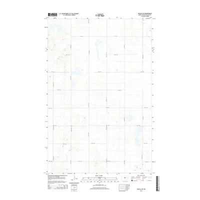
2014 Map of McVille SE
USGS Topo · Published 2014About this map
Hillesland Lake lies in the southeast corner of this rural landscape in Nelson County, representing the characteristic pothole topography of the North Dakota plains. The map reveals a strictly regulated grid of section roads, where thoroughfares like 31st St NE and 24th St NE intersect with north-south routes such as 115th Ave NE and 120th Ave NE. This pattern illustrates the enduring influence of the Public Land Survey System on the modern agricultural environment, where nearly every mile is delineated by a maintained road. The terrain is marked by numerous small depressions and seasonal water bodies typical of the region, providing a detailed look at the local drainage and land use during the early twenty-first century.
Find a feature on this map
15 named features on this map. Tap any name to fly to it.
Don’t see what you’re looking for? This feature index may not catch every label — zoom into the map to look around manually.
Map Details
Editions of this 2014 McVille SE Map
This is the sole edition of this map. No revisions or reprints were ever made.
Other maps of this area

1939 · Niagara
USGS Topo · 1:62,500

1942 · McVille
USGS Topo · 1:62,500

1952 · Grand Forks
USGS Topo · 1:250,000

1952 · New Rockford
USGS Topo · 1:250,000

1956 · New Rockford
USGS Topo · 1:250,000

1956 · Grand Forks
USGS Topo · 1:250,000

1961 · Kloten NW
USGS Topo · 1:24,000
1961 · McVille
USGS Topo · 1:24,000

1963 · Niagara SW
USGS Topo · 1:24,000
1963 · McVille SE
USGS Topo · 1:24,000