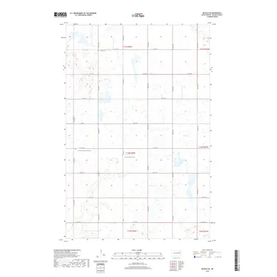
2018 Map of McVille SE
USGS Topo · Published 2018About this map
Glacial prairie potholes and marshy wetlands define this section of Nelson County, where the landscape is organized by the rigid geometry of the Public Land Survey System. The township lines of t150n r58w and surrounding ranges divide a territory marked by numerous small, unnamed water bodies and a sparse network of county roads like Co Rd 5. Genealogical interest is concentrated at several rural burial sites that reflect the area's denominational history, including Zion Lutheran Free Church Cem and Our Savior's Church Cem. In the southeastern corner, Hillesland Lake stands as the primary named aquatic feature. The map illustrates a contemporary rural environment where agriculture and drainage patterns dictate the placement of section-line roads such as 31st St NE and 117th Ave NE.
Find a feature on this map
25 named features on this map. Tap any name to fly to it.
Don’t see what you’re looking for? This feature index may not catch every label — zoom into the map to look around manually.
Map Details
Editions of this 2018 McVille SE Map
This is the sole edition of this map. No revisions or reprints were ever made.
Other maps of this area

1939 · Niagara
USGS Topo · 1:62,500

1942 · McVille
USGS Topo · 1:62,500

1952 · Grand Forks
USGS Topo · 1:250,000

1952 · New Rockford
USGS Topo · 1:250,000

1956 · New Rockford
USGS Topo · 1:250,000

1956 · Grand Forks
USGS Topo · 1:250,000

1961 · Kloten NW
USGS Topo · 1:24,000
1961 · McVille
USGS Topo · 1:24,000

1963 · Niagara SW
USGS Topo · 1:24,000
1963 · McVille SE
USGS Topo · 1:24,000