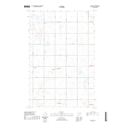
2020 Map of McVille SE
USGS Topo · Published 2020About this map
Nelson County prairie lands south of McVille are defined by a rhythmic grid of section lines and gravel roads. Scattered across this agricultural landscape are isolated points of community history, primarily preserved through local burial grounds. The Zion Lutheran Free Church Cem and Our Savior's Church Cem serve as quiet markers of the region's Scandinavian heritage and church-centered settlement patterns. The terrain is notably pocketed with small prairie wetlands and depressions, characteristic of the glacial till found throughout this part of North Dakota. Moving north, Melvin Cem sits along 31st St NE, anchoring a landscape where the primary human footprint is found in the intersection of numbered section roads like Co Rd 5 and 115th Ave NE.
Find a feature on this map
25 named features on this map. Tap any name to fly to it.
Don’t see what you’re looking for? This feature index may not catch every label — zoom into the map to look around manually.
Map Details
Editions of this 2020 McVille SE Map
This is the sole edition of this map. No revisions or reprints were ever made.
Other maps of this area

1939 · Niagara
USGS Topo · 1:62,500

1942 · McVille
USGS Topo · 1:62,500

1952 · Grand Forks
USGS Topo · 1:250,000

1952 · New Rockford
USGS Topo · 1:250,000

1956 · New Rockford
USGS Topo · 1:250,000

1956 · Grand Forks
USGS Topo · 1:250,000

1961 · Kloten NW
USGS Topo · 1:24,000
1961 · McVille
USGS Topo · 1:24,000

1963 · Niagara SW
USGS Topo · 1:24,000
1963 · McVille SE
USGS Topo · 1:24,000