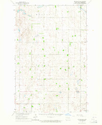
1963 Map of McVille SE
USGS Topo · Published 1964About this map
Glacial prairie potholes and scattered wetlands define this section of Nelson County, where the township boundaries of Melvin, Adler, Field, Rugby, Lee, and Ora converge. The landscape is a patchwork of agricultural field lines and small water bodies, notably Hillesland Lake in the southeast corner and the winding course of Goose Creek to the northeast. Rural life in the early 1960s was anchored by modest landmarks like Zion Ch and Our Savior Ch, providing essential community points for the surrounding farmsteads.
Find a feature on this map
11 named features on this map. Tap any name to fly to it.
Don’t see what you’re looking for? This feature index may not catch every label — zoom into the map to look around manually.
Map Details
Editions of this 1963 McVille SE Map
This is the sole edition of this map. No revisions or reprints were ever made.
Other maps of this area

1939 · Niagara
USGS Topo · 1:62,500

1942 · McVille
USGS Topo · 1:62,500

1952 · Grand Forks
USGS Topo · 1:250,000

1952 · New Rockford
USGS Topo · 1:250,000

1956 · New Rockford
USGS Topo · 1:250,000

1956 · Grand Forks
USGS Topo · 1:250,000

1961 · Kloten NW
USGS Topo · 1:24,000
1961 · McVille
USGS Topo · 1:24,000

1963 · Niagara SW
USGS Topo · 1:24,000

1966 · Grand Forks
USGS Topo · 1:250,000