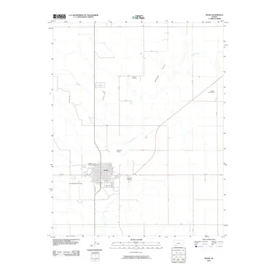
2010 Map of Meade
USGS Topo · Published 2010About this map
Meade serves as the central hub of this Kansas landscape, where the grid of city streets like S Blaine St and Vine St meets the open expanse of the Artesian Valley. The settlement pattern is defined by the winding course of Crooked Creek, which meanders through the township and past the Meade County Fairgrounds. This 2010 survey reflects a rural community anchored by its essential landmarks and transportation nodes, including the Meade Municipal Airport to the southwest and Watson Landing Field to the northeast. Genealogists will find the locations of Lockhart Cemetery and Graceland Cemetery clearly marked, offering spatial context for local family history. The surrounding territory is divided into a rigorous section-line road system, with labels such as H Rd and 17 Rd defining the agricultural boundaries of the high plains.
Find a feature on this map
30 named features on this map. Tap any name to fly to it.
Don’t see what you’re looking for? This feature index may not catch every label — zoom into the map to look around manually.
Map Details
Editions of this 2010 Meade Map
This is the sole edition of this map. No revisions or reprints were ever made.
Other maps of this area

1892 · Meade
USGS Topo · 1:125,000

1955 · Dodge City
USGS Topo · 1:250,000

1958 · Dodge City
USGS Topo · 1:250,000

1959 · Dodge City
USGS Topo · 1:250,000

1962 · Irish Flats NE
USGS Topo · 1:24,000

1963 · Lake Larrabee
USGS Topo · 1:24,000

1963 · Meade
USGS Topo · 1:24,000

1963 · Missler
USGS Topo · 1:24,000

1967 · Fowler SW
USGS Topo · 1:24,000
1968 · Meade NW
USGS Topo · 1:24,000