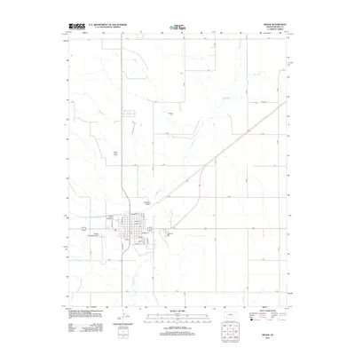
2012 Map of Meade
USGS Topo · Published 2012About this map
Artesian Valley defines the landscape north of the township, where the winding path of Crooked Cr snakes through the High Plains of Meade County. The grid-patterned streets of the settlement are well-documented, showing a clear layout from Madison St down to Walnut St, centered around local infrastructure such as the Meade County Fairgrounds. On the outskirts, civic and family history is preserved at Graceland Cem and the more remote Lockhart Cem. The presence of the Meade Municipal Airport west of the main cluster of homes reflects the 21st-century connectivity of this rural hub, while the surrounding landscape remains dominated by numbered section roads like H RD and P RD.
Find a feature on this map
31 named features on this map. Tap any name to fly to it.
Don’t see what you’re looking for? This feature index may not catch every label — zoom into the map to look around manually.
Map Details
Editions of this 2012 Meade Map
This is the sole edition of this map. No revisions or reprints were ever made.
Other maps of this area

1892 · Meade
USGS Topo · 1:125,000

1955 · Dodge City
USGS Topo · 1:250,000

1958 · Dodge City
USGS Topo · 1:250,000

1959 · Dodge City
USGS Topo · 1:250,000

1962 · Irish Flats NE
USGS Topo · 1:24,000

1963 · Lake Larrabee
USGS Topo · 1:24,000

1963 · Meade
USGS Topo · 1:24,000

1963 · Missler
USGS Topo · 1:24,000

1967 · Fowler SW
USGS Topo · 1:24,000
1968 · Meade NW
USGS Topo · 1:24,000