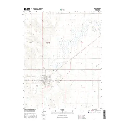
2016 Map of Meade
USGS Topo · Published 2016About this map
Meade serves as the focal point of this southwestern Kansas landscape, where the town grid is defined by streets such as N Carthage and E Madison St. This 2016 survey illustrates a transition from the structured residential blocks of the town center to the expansive agrarian lands of the Artesian Valley. Significant local landmarks include Graceland Cem to the east and Meade Municipal Airport to the south, while the northern reaches contain the historic Lockhart Cem. The geography is heavily influenced by the meandering path of Crooked Cr, which carves through the terrain alongside numerous section-line roads like 21 Rd and H Rd. To the northeast, a collection of small water bodies including Mayberry Lake, Sedlock Lake, and McClane Lake provide distinct hydrological features in an otherwise semi-arid plains environment.
Find a feature on this map
51 named features on this map. Tap any name to fly to it.
Don’t see what you’re looking for? This feature index may not catch every label — zoom into the map to look around manually.
Map Details
Editions of this 2016 Meade Map
This is the sole edition of this map. No revisions or reprints were ever made.
Other maps of this area

1892 · Meade
USGS Topo · 1:125,000

1955 · Dodge City
USGS Topo · 1:250,000

1958 · Dodge City
USGS Topo · 1:250,000

1959 · Dodge City
USGS Topo · 1:250,000

1962 · Irish Flats NE
USGS Topo · 1:24,000

1963 · Lake Larrabee
USGS Topo · 1:24,000

1963 · Meade
USGS Topo · 1:24,000

1963 · Missler
USGS Topo · 1:24,000

1967 · Fowler SW
USGS Topo · 1:24,000
1968 · Meade NW
USGS Topo · 1:24,000