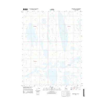
2015 Map of Meade River D-1 NW
USGS Topo · Published 2015About this map
Inaru River meanders across this Arctic landscape, forming the primary drainage through a mosaic of thaw lakes and wetlands. The hydrology of the North Slope is the defining characteristic here, dominated by the elongated Ekalgruak Lake in the northeastern quadrant and the smaller Sisgravik Lake to the east. This 2015 survey by the U.S. Geological Survey documents the intricate water patterns of the Arctic coastal plain, where the lack of vertical relief creates a complex network of seasonal channels and permanent basins. The township and range lines of the Public Land Survey System, including t19n r18w and t18n r17w, provide the only geometric structure to this otherwise fluid terrain. This map serves as a vital record for understanding the natural water systems and remote geography of the Alaska North Slope Borough in the early 21st century.
Find a feature on this map
7 named features on this map. Tap any name to fly to it.
Don’t see what you’re looking for? This feature index may not catch every label — zoom into the map to look around manually.
Map Details
Editions of this 2015 Meade River D-1 NW Map
This is the sole edition of this map. No revisions or reprints were ever made.
Other maps of this area

1945 · Barrow
USGS Topo · 1:250,000

1949 · Barrow
USGS Topo · 1:250,000

1951 · Meade River
USGS Topo · 1:250,000

1955 · Barrow
USGS Topo · 1:250,000

1955 · Meade River
USGS Topo · 1:250,000

1955 · Barrow A-4
USGS Topo · 1:63,360

1955 · Barrow A-3
USGS Topo · 1:63,360

1955 · Meade River D-2
USGS Topo · 1:63,360
1955 · Meade River D-1
USGS Topo · 1:63,360
1962 · Meade River D-2
USGS Topo · 1:50,000