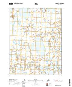
2020 Map of Meade River D-2 NE
USGS Topo · Published 2020About this map
Inaru River meanders across the southern landscape of this Arctic coastal plain, defining the drainage patterns for a region dominated by permafrost and shallow water bodies. This 2020 topographic map of the North Slope reflects a wilderness shaped by extreme seasonal shifts, where vast wetlands and thermokarst features like Sukok Lake and Evrulivik Lake dominate the geography. The map utilizes 2011 SPOT imagery and hydrography data from the National Hydrography Dataset to detail the intricate network of water and marshland that characterizes this part of Alaska. For researchers, the Public Land Survey System grids, including t19n r19w and t19n r18w, provide the structural framework for understanding land division in this largely uninhabited portion of the borough.
Find a feature on this map
7 named features on this map. Tap any name to fly to it.
Don’t see what you’re looking for? This feature index may not catch every label — zoom into the map to look around manually.
Map Details
Editions of this 2020 Meade River D-2 NE Map
This is the sole edition of this map. No revisions or reprints were ever made.
Other maps of this area

1945 · Barrow
USGS Topo · 1:250,000

1949 · Barrow
USGS Topo · 1:250,000

1951 · Meade River
USGS Topo · 1:250,000

1955 · Barrow
USGS Topo · 1:250,000

1955 · Meade River
USGS Topo · 1:250,000

1955 · Barrow A-4
USGS Topo · 1:63,360

1955 · Barrow A-5
USGS Topo · 1:63,360

1955 · Meade River D-2
USGS Topo · 1:63,360
1955 · Meade River D-1
USGS Topo · 1:63,360
1962 · Meade River D-2
USGS Topo · 1:50,000