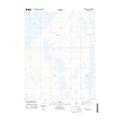
2014 Map of Meade River D-3 NE
USGS Topo · Published 2014About this map
The Chukchi Sea coastline defines the northwest corner of this remote Alaskan landscape, where the sea meets a complex system of thermokarst lakes and coastal tundra. The terrain is characterized by low-lying wetlands and seasonal drainage patterns, most notably Niklavik Cr flowing through the southern portion of the survey area. This 2014 data captures the hydrologic state of the North Slope, documenting the intricate network of water bodies such as Tractor Lake. The map illustrates the Township and Range system over an area largely devoid of permanent human infrastructure, providing a detailed look at the natural topography and shoreline before shifting climate patterns impact the Arctic coast. Researchers can observe the density of unnamed ponds and the specific orientation of larger lakes, which often align with prevailing winds in this permafrost-dominated region.
Find a feature on this map
7 named features on this map. Tap any name to fly to it.
Don’t see what you’re looking for? This feature index may not catch every label — zoom into the map to look around manually.
Map Details
Editions of this 2014 Meade River D-3 NE Map
This is the sole edition of this map. No revisions or reprints were ever made.
Other maps of this area

1945 · Barrow
USGS Topo · 1:250,000

1949 · Barrow
USGS Topo · 1:250,000

1951 · Meade River
USGS Topo · 1:250,000

1955 · Barrow
USGS Topo · 1:250,000

1955 · Meade River
USGS Topo · 1:250,000

1955 · Barrow A-5
USGS Topo · 1:63,360

1955 · Meade River D-2
USGS Topo · 1:63,360

1955 · Meade River D-3
USGS Topo · 1:63,360
1962 · Meade River D-3
USGS Topo · 1:50,000
1962 · Meade River D-2
USGS Topo · 1:50,000