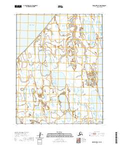
2020 Map of Meade River D-3 NE
USGS Topo · Published 2020About this map
The Chukchi Sea coastline meets the immense, water-logged terrain of Alaska's North Slope in this recent coastal survey. The landscape is defined by an intricate network of thermokarst lakes and slow-moving drainages, including the aptly named Tractor Lake in the southeastern quadrant. Small arctic waterways like Siugat Cr, Singat Cr, and Niklavik Cr carve through the tundra, illustrating the fluid boundaries between land and water in this permafrost-rich environment. This map captures the remote character of the region, where surveyors have meticulously tracked the shifting shorelines and hydrologic patterns that dominate the North Slope Borough.
Find a feature on this map
9 named features on this map. Tap any name to fly to it.
Don’t see what you’re looking for? This feature index may not catch every label — zoom into the map to look around manually.
Map Details
Editions of this 2020 Meade River D-3 NE Map
This is the sole edition of this map. No revisions or reprints were ever made.
Other maps of this area

1945 · Barrow
USGS Topo · 1:250,000

1949 · Barrow
USGS Topo · 1:250,000

1951 · Meade River
USGS Topo · 1:250,000

1955 · Barrow
USGS Topo · 1:250,000

1955 · Meade River
USGS Topo · 1:250,000

1955 · Barrow A-5
USGS Topo · 1:63,360

1955 · Meade River D-2
USGS Topo · 1:63,360

1955 · Meade River D-3
USGS Topo · 1:63,360
1962 · Meade River D-3
USGS Topo · 1:50,000
1962 · Meade River D-2
USGS Topo · 1:50,000