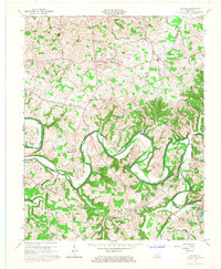
1965 Map of Meador
USGS Topo · Published 1967About this map
The Barren River defines this portion of the Kentucky landscape, shown here as it transitioned into a managed waterway following the construction of the Barren River Dam. The map captures the newly formed Barren River Reservoir and its inundation zones, which altered the historical access points along the river's winding course. While modern infrastructure like pipelines and several Oil Wells appear, the area remains anchored by long-standing rural communities such as Meador, Kepler, and Martinsville. Evidence of older transportation methods survives in labels for Martinsville Ford and Port Oliver Ford, which once provided vital crossings before the reservoir's creation. Local social life is mapped through numerous country churches, including Lawrence Chapel and Mt Union Ch, along with the Pleasant Grove School, providing a detailed look at the settlement patterns of Warren, Barren, and Allen Counties.
Find a feature on this map
42 named features on this map. Tap any name to fly to it.
Don’t see what you’re looking for? This feature index may not catch every label — zoom into the map to look around manually.
Map Details
Editions of this 1965 Meador Map
This is the sole edition of this map. No revisions or reprints were ever made.
Other maps of this area

1921 · Bowling Green
USGS Topo · 1:62,500

1922 · Brownsville
USGS Topo · 1:62,500

1922 · Mammoth Cave
USGS Topo · 1:62,500

1923 · Bowling Green
USGS Topo · 1:62,500

1923 · Mammoth Cave
USGS Topo · 1:62,500

1923 · Brownsville
USGS Topo · 1:62,500

1926 · Scottsville
USGS Topo · 1:62,500

1954 · Evansville
USGS Topo · 1:250,000

1954 · Austin
USGS Topo · 1:24,000

1954 · Bristow
USGS Topo · 1:24,000