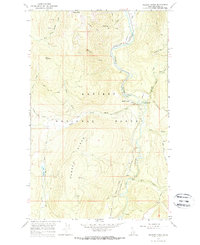
1965 Map of Meadow Creek
USGS Topo · Published 1967About this map
Kaniksu National Forest defines this high-elevation landscape in Boundary County, where the Moyie River carves a deep valley corridor. The small settlement of Eileen sits along the river's edge, positioned near a strategic Gaging Station and the Spokane International railroad line. This rail connection provided a vital link through the Panhandle's timber and mountain terrain, following the natural course of the water.
Find a feature on this map
30 named features on this map. Tap any name to fly to it.
Don’t see what you’re looking for? This feature index may not catch every label — zoom into the map to look around manually.
Map Details
Editions of this 1965 Meadow Creek Map
2 editions found
Other maps of this area

1911 · Priest Lake
USGS Topo · 1:250,000

1913 · Priest Lake
USGS Topo · 1:250,000

1958 · Sandpoint
USGS Topo · 1:250,000

1963 · Sandpoint
USGS Topo · 1:250,000
1965 · Curley Creek
USGS Topo · 1:24,000

1965 · Meadow Creek
USGS Topo · 1:24,000

1965 · Eastport
USGS Topo · 1:24,000

1965 · Ritz
USGS Topo · 1:24,000
1965 · Line Point
USGS Topo · 1:24,000
1965 · Moyie Springs
USGS Topo · 1:24,000