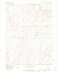
1966 Map of Meadow Creek Lake
USGS Topo · Published 1969About this map
White River National Forest defines the rugged geography of this 1960s survey, centered on the high terrain of Clark Ridge and Clinetop Mesa. The map details a landscape transition from the deep White River Canyon in the north to the seasonal high-country outposts like Clark Cabin and Meadow Creek Cow Camp. This region was primary backcountry for cattle and timber at the time, accessed by the New Castle Buford Road and historic paths like the Ute Trail. Hydrological features are prominent, including the subterranean Spring Cave and Meadow Creek Lake, alongside numerous seasonal water sources such as Hiner Spring and Cave Creek. The map documents the forest's development for recreation with several established sites including Cliff Lakes Campground and South Fork Campground.
Find a feature on this map
30 named features on this map. Tap any name to fly to it.
Don’t see what you’re looking for? This feature index may not catch every label — zoom into the map to look around manually.
Map Details
Editions of this 1966 Meadow Creek Lake Map
3 editions found
Other maps of this area

1906 · Grand Hogback
USGS Topo · 1:125,000

1910 · Grand Hogback
USGS Topo · 1:125,000

1927 · Glenwood Springs
USGS Topo · 1:125,000

1930 · Glenwood Springs
USGS Topo · 1:125,000

1957 · Leadville
USGS Topo · 1:250,000

1959 · Leadville
USGS Topo · 1:250,000

1960 · Leadville
USGS Topo · 1:250,000

1962 · Leadville
USGS Topo · 1:250,000

1964 · Leadville
USGS Topo · 1:250,000
1966 · Rifle Falls
USGS Topo · 1:24,000