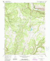
1966 Map of Meadow Creek Lake
USGS Topo · Published 1988About this map
White River National Forest defines the landscape of this high-country survey, where the Rio Blanco Co Garfield Co boundary line bisects deep river canyons and high mesas. The 1960s terrain is characterized by a network of traditional mountain routes, including the historic Ute Trail, which winds past Meadow Creek Lake. Evidence of local ranching and seasonal grazing is found at sites like Meadow Creek Cow Camp and Clark Cabin Spring. In the northern section, the Flat Tops Wilderness preserves a rugged expanse of peaks and canyons, notably the South Fork White River as it cuts through the landscape. Recreational developments of the mid-20th century are marked by the South Fork Campground and Meadow Creek Campground, serving as basepoints for those navigating the New Castle Buford Road and various pack trails.
Find a feature on this map
29 named features on this map. Tap any name to fly to it.
Don’t see what you’re looking for? This feature index may not catch every label — zoom into the map to look around manually.
Map Details
Editions of this 1966 Meadow Creek Lake Map
3 editions found
Other maps of this area

1906 · Grand Hogback
USGS Topo · 1:125,000

1910 · Grand Hogback
USGS Topo · 1:125,000

1927 · Glenwood Springs
USGS Topo · 1:125,000

1930 · Glenwood Springs
USGS Topo · 1:125,000

1957 · Leadville
USGS Topo · 1:250,000

1959 · Leadville
USGS Topo · 1:250,000

1960 · Leadville
USGS Topo · 1:250,000

1962 · Leadville
USGS Topo · 1:250,000

1964 · Leadville
USGS Topo · 1:250,000
1966 · Rifle Falls
USGS Topo · 1:24,000