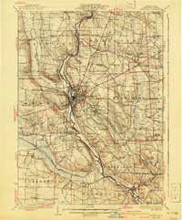
1925 Map of Meadville
USGS Topo · Published 1940About this map
French Creek carves a deep valley through the center of this Crawford County landscape, serving as the primary corridor for the region's transport and industry. The city of Meadville dominates the central terrace, showing a dense grid of streets and the extensive infrastructure of the Water Works and County Farm. This era marks the height of the local rail network, where the Erie RR and the Bessemer and Lake Erie RR intersect with the interurban Northwestern Electric RR, facilitating movement between Saegerstown and Cochranton.
Find a feature on this map
106 named features on this map. Tap any name to fly to it.
Don’t see what you’re looking for? This feature index may not catch every label — zoom into the map to look around manually.
Map Details
Editions of this 1925 Meadville Map
3 editions found

Other maps of this area

1900 · Girard
USGS Topo · 1:62,500

1906 · Linesville
USGS Topo · 1:62,500

1908 · Shenango
USGS Topo · 1:62,500

1908 · Linesville
USGS Topo · 1:62,500

1909 · Franklin
USGS Topo · 1:62,500

1911 · Franklin
USGS Topo · 1:62,500

1911 · Stoneboro
USGS Topo · 1:62,500

1913 · Stoneboro
USGS Topo · 1:62,500

1923 · Meadville
USGS Topo · 1:62,500

1923 · Cambridge Springs
USGS Topo · 1:62,500