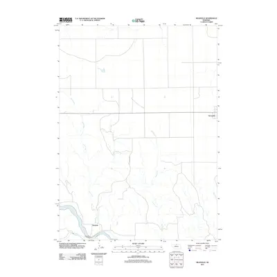
2011 Map of Meadville
USGS Topo · Published 2011About this map
The Niobrara River carves a deep valley across the southern portion of this landscape, defining the rural character of Keya Paha County. Along its banks, the small settlement of Meadville serves as a historic crossing point, anchored by the Meadville Bridge near the confluence with Plum Creek. To the north, the terrain transitions into a more structured agricultural grid, where the community of Springview sits near the eastern edge of the survey. The land is drained by a series of south-flowing waterways, including Rock Creek, Jewett Creek, and Dry Creek, which cut through the high plains before meeting the primary river channel. This network of creeks and the major artery of Meadville Rd illustrate a landscape shaped by its water sources and the essential transportation routes connecting these isolated Nebraska settlements.
Find a feature on this map
10 named features on this map. Tap any name to fly to it.
Don’t see what you’re looking for? This feature index may not catch every label — zoom into the map to look around manually.
Map Details
Editions of this 2011 Meadville Map
This is the sole edition of this map. No revisions or reprints were ever made.
Other maps of this area

1949 · Dutch Creek
USGS Topo · 1:24,000

1950 · Bassett NW
USGS Topo · 1:24,000

1950 · Meadville
USGS Topo · 1:24,000

1950 · Huddle Table
USGS Topo · 1:24,000

1950 · Dutch Creek
USGS Topo · 1:24,000

1954 · Ainsworth NW
USGS Topo · 1:24,000

1955 · O'Neill
USGS Topo · 1:250,000

1959 · O'Neill
USGS Topo · 1:250,000
1964 · Meadville NW
USGS Topo · 1:24,000
1964 · Springview
USGS Topo · 1:24,000