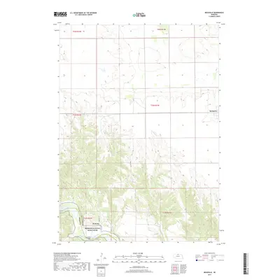
2017 Map of Meadville
USGS Topo · Published 2017About this map
Niobrara National Scenic River defines the southern portion of this landscape, where the Niobrara River carves through the terrain along the border of Brown and Keya Paha counties. The small settlement of Meadville sits just north of the water, connected by the Meadville Bridge which serves as a vital crossing point in this sparsely populated region. To the northeast, the town of Springview marks a primary center of activity, positioned on the higher ground away from the river breaks.
Find a feature on this map
17 named features on this map. Tap any name to fly to it.
Don’t see what you’re looking for? This feature index may not catch every label — zoom into the map to look around manually.
Map Details
Editions of this 2017 Meadville Map
This is the sole edition of this map. No revisions or reprints were ever made.
Other maps of this area

1949 · Dutch Creek
USGS Topo · 1:24,000

1950 · Bassett NW
USGS Topo · 1:24,000

1950 · Meadville
USGS Topo · 1:24,000

1950 · Huddle Table
USGS Topo · 1:24,000

1950 · Dutch Creek
USGS Topo · 1:24,000

1954 · Ainsworth NW
USGS Topo · 1:24,000

1955 · O'Neill
USGS Topo · 1:250,000

1959 · O'Neill
USGS Topo · 1:250,000
1964 · Meadville NW
USGS Topo · 1:24,000
1964 · Springview
USGS Topo · 1:24,000