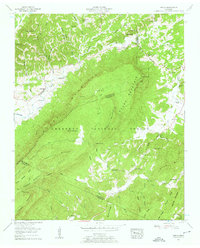
1957 Map of Mecca
USGS Topo · Published 1959About this map
Starr Mountain dominates this landscape along the border of McMinn and Monroe Counties, rising sharply between the Conasauga Creek and Cane Creek drainages. In the late 1950s, this area of the Cherokee National Forest was defined by scattered rural congregations and family cemeteries. Small communities like Mecca and Conasauga are shown alongside spiritual hubs such as Wesley Chapel, House of Prayer, and Maple Springs Ch. The topography is particularly intricate, featuring a series of named knobs including Cartwright Knob and Almon Knob, while a lookout tower stands watch over the ridge line. For genealogists and local historians, the map provides precise locations for burial grounds like Hamby Cem, Cain Cem, and Adams Cem, situated near the winding Bullet Creek.
Find a feature on this map
88 named features on this map. Tap any name to fly to it.
Don’t see what you’re looking for? This feature index may not catch every label — zoom into the map to look around manually.
Map Details
Editions of this 1957 Mecca Map
4 editions found
Other maps of this area

1886 · Cleveland
USGS Topo · 1:125,000

1892 · Cleveland
USGS Topo · 1:125,000

1893 · Murphy
USGS Topo · 1:125,000

1895 · Cleveland
USGS Topo · 1:125,000

1901 · Cleveland
USGS Topo · 1:125,000

1914 · Murphy
USGS Topo · 1:125,000

1934 · Mount Vernon
USGS Topo · 1:24,000

1934 · Mecca
USGS Topo · 1:24,000

1934 · Englewood
USGS Topo · 1:24,000

1934 · Tellico Plains
USGS Topo · 1:24,000