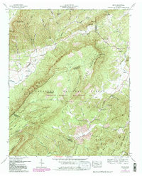
1957 Map of Mecca
USGS Topo · Published 1980About this map
Starr Mountain dominates this landscape along the border of McMinn and Monroe counties, anchoring a region defined by the wooded expanse of the Cherokee National Forest. In the late 1950s, the rural community of Mecca and the settlement at Rural Vale served as focal points for local life, evidenced by a network of country churches including Wesley Chapel and Rural Vale Ch. The terrain transitions from the high ridges of Chestnut Mountain and Hogback Ridge into deep drainages like Bullet Creek, where the Bullet Creek Falls are located. Genealogists will find significant value in the distribution of family and community burial sites, from the Lick Creek Cem in the north to the Hamby Cem further south. The map also records the site of a Lookout tower on a prominent ridge, a critical piece of infrastructure for the Cherokee Wildlife Management Area.
Find a feature on this map
59 named features on this map. Tap any name to fly to it.
Don’t see what you’re looking for? This feature index may not catch every label — zoom into the map to look around manually.
Map Details
Editions of this 1957 Mecca Map
4 editions found
Other maps of this area

1886 · Cleveland
USGS Topo · 1:125,000

1892 · Cleveland
USGS Topo · 1:125,000

1893 · Murphy
USGS Topo · 1:125,000

1895 · Cleveland
USGS Topo · 1:125,000

1901 · Cleveland
USGS Topo · 1:125,000

1914 · Murphy
USGS Topo · 1:125,000

1934 · Mount Vernon
USGS Topo · 1:24,000

1934 · Mecca
USGS Topo · 1:24,000

1934 · Englewood
USGS Topo · 1:24,000

1934 · Tellico Plains
USGS Topo · 1:24,000