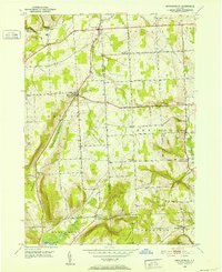
1950 Map of Mecklenburg
USGS Topo · Published 1952About this map
Mecklenburg sits at a crossroads in this mid-century view of the Finger Lakes region, where the upland terrain of the Schuyler and Tompkins County line meets the valley floor. The map highlights a series of small, rural settlements including Perry City, Enfield, and Trumbull Corners, connected by a network of historic routes like the Catskill Turnpike and Connecticut Hill Road. The landscape is defined by its dramatic relief, from the heights of Buck Hill and Stevenson Hill down to the shores of Cayuta Lake. Local history is preserved in the location of the Mecklenburg Cem and various unnamed cemeteries, alongside named corners such as Millers Corners and Bostwick Corners. The presence of a Radio Tower and various benchmark elevations reflects the systematic topographical efforts of the era, while the drainage of Taughannock Creek and Enfield Creek illustrates the intricate water network feeding the larger regional basins.
Find a feature on this map
41 named features on this map. Tap any name to fly to it.
Don’t see what you’re looking for? This feature index may not catch every label — zoom into the map to look around manually.
Map Details
Editions of this 1950 Mecklenburg Map
3 editions found
Other maps of this area

1893 · Ithaca
USGS Topo · 1:62,500

1895 · Ithaca
USGS Topo · 1:62,500

1898 · Watkins Glen
USGS Topo · 1:62,500

1901 · Watkins
USGS Topo · 1:62,500

1902 · Genoa
USGS Topo · 1:62,500

1902 · Ovid
USGS Topo · 1:62,500

1905 · Watkins Glen
USGS Topo · 1:125,000

1942 · Ludlowville
USGS Topo · 1:24,000

1942 · Lodi
USGS Topo · 1:24,000

1942 · Trumansburg
USGS Topo · 1:24,000