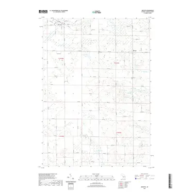
2019 Map of Mecosta
USGS Topo · Published 2019About this map
Mecosta and Remus serve as the primary hubs of this landscape in central Michigan, where a dense network of local roads and sections lines organizes the terrain. The northern half of the sheet is marked by the Br Little Muskegon River flowing near Mecosta, while the eastern reaches are defined by the Pine River and Pony Cr. Numerous small water bodies such as Pickerel Lake, Schoner Lake, and Mud Lake dot the area, often surrounded by expansive wetland areas that have influenced the local road pattern. Genealogists will find several burial grounds across the townships, including Morgan Cem, Saint Michael Cem, Morton Cem, and Wamboldt Cem. The map illustrates a rural interior reliant on a grid of numbered roads like 9 Mile Rd and 30th Ave, connecting isolated farmsteads and small crossroads communities within the larger Wheatland and Morton Township regions.
Find a feature on this map
68 named features on this map. Tap any name to fly to it.
Don’t see what you’re looking for? This feature index may not catch every label — zoom into the map to look around manually.
Map Details
Editions of this 2019 Mecosta Map
This is the sole edition of this map. No revisions or reprints were ever made.
Other maps of this area

1954 · Midland
USGS Topo · 1:250,000

1958 · Midland
USGS Topo · 1:250,000

1958 · Big Rapids
USGS Topo · 1:62,500

1959 · Midland
USGS Topo · 1:250,000

1959 · Howard City
USGS Topo · 1:62,500

1964 · Edmore
USGS Topo · 1:24,000

1964 · Six Lakes
USGS Topo · 1:24,000

1964 · Mecosta NW
USGS Topo · 1:24,000

1964 · Blanchard
USGS Topo · 1:24,000

1964 · Mecosta
USGS Topo · 1:24,000