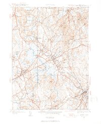
1945 Map of Medfield
USGS Topo · Published 1954About this map
The Charles River meanders through the heart of this Norfolk County landscape, defining the character of local life in the mid-1940s. The sprawling campus of the Medfield State Hospital stands as a significant institutional landmark near Harding, while the Norfolk Hunt Club reflects the region's long-standing equestrian traditions. The rail network of the New York New Haven and Hartford RR provides essential connectivity, with Medfield Junction and Farm St Sta serving as vital nodes for transportation and industry.
Find a feature on this map
71 named features on this map. Tap any name to fly to it.
Don’t see what you’re looking for? This feature index may not catch every label — zoom into the map to look around manually.
Map Details
Editions of this 1945 Medfield Map
3 editions found
Other maps of this area

1886 · Dedham
USGS Topo · 1:62,500

1886 · Framingham
USGS Topo · 1:62,500

1887 · Franklin
USGS Topo · 1:62,500

1889 · Franklin
USGS Topo · 1:62,500

1889 · Framingham
USGS Topo · 1:62,500

1893 · Franklin
USGS Topo · 1:62,500

1893 · Boston
USGS Topo · 1:62,500

1894 · Dedham
USGS Topo · 1:62,500

1894 · Framingham
USGS Topo · 1:62,500

1903 · Boston
USGS Topo · 1:62,500