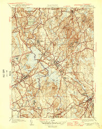
1946 Map of Medfield
USGS Topo · Published 1946About this map
The Charles River meanders extensively through this 1940s landscape, defining the borders of several Norfolk County towns. A prominent feature is the expansive grounds of the Medfield State Hospital, which includes its own specialized infrastructure like the Medfield State Hospital rail spurs and a dedicated Sewage Disposal plant near the riverbanks. The transportation network is anchored by the New Haven and Hartford Rr, with critical local nodes at Medfield Junction and the Farm St Sta serving the surrounding communities.
Find a feature on this map
75 named features on this map. Tap any name to fly to it.
Don’t see what you’re looking for? This feature index may not catch every label — zoom into the map to look around manually.
Map Details
Editions of this 1946 Medfield Map
2 editions found
Other maps of this area

1886 · Dedham
USGS Topo · 1:62,500

1886 · Framingham
USGS Topo · 1:62,500

1887 · Franklin
USGS Topo · 1:62,500

1889 · Franklin
USGS Topo · 1:62,500

1889 · Framingham
USGS Topo · 1:62,500

1893 · Franklin
USGS Topo · 1:62,500

1893 · Boston
USGS Topo · 1:62,500

1894 · Dedham
USGS Topo · 1:62,500

1894 · Framingham
USGS Topo · 1:62,500

1903 · Boston
USGS Topo · 1:62,500