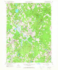
1957 Map of Medfield
USGS Topo · Published 1967About this map
The Charles River forms a winding corridor through this landscape, separating the communities of Millis, Sherborn, and Medfield. During the mid-century, the area remained defined by its institutional and recreational lands, most notably the expansive Medfield State Hospital complex and the Rocky Woods Reservation. The rail infrastructure of the New York New Haven and Hartford railroad is prominent, featuring key stops like Farm Street Station and the industrial hub at Medfield Junction.
Find a feature on this map
103 named features on this map. Tap any name to fly to it.
Don’t see what you’re looking for? This feature index may not catch every label — zoom into the map to look around manually.
Map Details
Editions of this 1957 Medfield Map
2 editions found
Other maps of this area

1886 · Dedham
USGS Topo · 1:62,500

1886 · Framingham
USGS Topo · 1:62,500

1887 · Franklin
USGS Topo · 1:62,500

1889 · Franklin
USGS Topo · 1:62,500

1889 · Framingham
USGS Topo · 1:62,500

1893 · Franklin
USGS Topo · 1:62,500

1893 · Boston
USGS Topo · 1:62,500

1894 · Dedham
USGS Topo · 1:62,500

1894 · Framingham
USGS Topo · 1:62,500

1903 · Boston
USGS Topo · 1:62,500