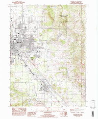
1983 Map of Medford East
USGS Topo · Published 1983About this map
Phoenix and the smaller settlements of Larson and Voorhies define the southern corridor of this 1983 survey, situated along the fertile agricultural and residential margins of the Rogue Valley. The landscape is characterized by the transition from the urbanized edges of Medford to the rising elevations of the Cascade foothills, most notably at Roxy Ann Peak within Prescott Park. This era shows a community in mid-growth, balancing significant public infrastructure like the Medford-Jackson County Airport, Providence Hospital, and Rogue Valley Memorial Hosp with the natural drainage systems of Bear Creek and Larson Creek.
Find a feature on this map
30 named features on this map. Tap any name to fly to it.
Don’t see what you’re looking for? This feature index may not catch every label — zoom into the map to look around manually.
Map Details
Editions of this 1983 Medford East Map
This is the sole edition of this map. No revisions or reprints were ever made.
Other maps of this area

1891 · Ashland
USGS Topo · 1:250,000

1893 · Ashland
USGS Topo · 1:250,000

1897 · Ashland
USGS Topo · 1:250,000

1938 · Medford
USGS Topo · 1:125,000

1954 · Medford
USGS Topo · 1:62,500

1954 · Lakecreek
USGS Topo · 1:62,500

1954 · Talent
USGS Topo · 1:62,500

1954 · Ashland
USGS Topo · 1:62,500

1955 · Medford
USGS Topo · 1:250,000

1957 · Medford
USGS Topo · 1:250,000