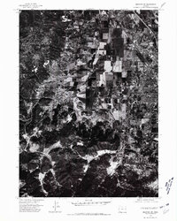
1974 Map of Medford SW
USGS Topo · Published 1981About this map
Central Point anchors the northern portion of this 1974 orthophotoquad, which captures a transition between the valley floor's dense grid and the foothills of the Jackson County landscape. This aerial perspective, derived from imagery taken in mid-July, reveals the geometric precision of the region's agricultural allotments and the developing suburban fringes of the mid-1970s. The contrast between the cultivated orchards and fields near Central Point and the darker, timbered rising ground to the south and west provides a clear view of how topographic shifts dictated local land use. For those studying the evolution of Oregon's Rogue Valley, this survey serves as a vital record of rural and urban patterns before the significant expansion of the late 20th century.
Find a feature on this map
1 named feature on this map. Tap any name to fly to it.
Don’t see what you’re looking for? This feature index may not catch every label — zoom into the map to look around manually.
Map Details
Editions of this 1974 Medford SW Map
2 editions found
Other maps of this area

1891 · Ashland
USGS Topo · 1:250,000

1893 · Ashland
USGS Topo · 1:250,000

1897 · Ashland
USGS Topo · 1:250,000

1908 · Grants Pass
USGS Topo · 1:125,000

1938 · Medford
USGS Topo · 1:125,000

1954 · Medford
USGS Topo · 1:62,500

1954 · Gold Hill
USGS Topo · 1:62,500

1954 · Talent
USGS Topo · 1:62,500

1954 · Ruch
USGS Topo · 1:62,500

1955 · Medford
USGS Topo · 1:250,000