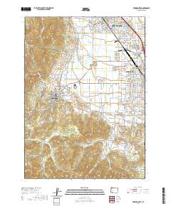
2020 Map of Medford West
USGS Topo · Published 2020About this map
The hills of western Medford and the historic streets of Jacksonville form the heart of this landscape in Jackson County. The area is defined by a sophisticated network of water management, including the Phoenix Canal, Hopkins Canal, and the Talent Middle Canal, which feed the surrounding valley. Along the western edge, the terrain transitions into the steep elevations of Britt Ridge and Britt Canyon, where Rich Gulch and Poormans Cr descend toward the valley floor. Transportation history is visible through labels for the Old Military Rd and Old Stage Rd, which parallel modern corridors. Genealogical sites are well-represented by the historic Jacksonville Cem, Griffin Creek Cem, and Memory Gardens Cem, providing specific points of interest for local researchers and family historians.
Find a feature on this map
116 named features on this map. Tap any name to fly to it.
Don’t see what you’re looking for? This feature index may not catch every label — zoom into the map to look around manually.
Map Details
Editions of this 2020 Medford West Map
This is the sole edition of this map. No revisions or reprints were ever made.
Other maps of this area

1891 · Ashland
USGS Topo · 1:250,000

1893 · Ashland
USGS Topo · 1:250,000

1897 · Ashland
USGS Topo · 1:250,000

1908 · Grants Pass
USGS Topo · 1:125,000

1938 · Medford
USGS Topo · 1:125,000

1954 · Medford
USGS Topo · 1:62,500

1954 · Gold Hill
USGS Topo · 1:62,500

1954 · Talent
USGS Topo · 1:62,500

1954 · Ruch
USGS Topo · 1:62,500

1955 · Medford
USGS Topo · 1:250,000