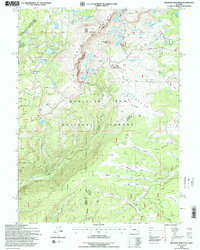
1992 Map of Medicine Bow Peak
USGS Topo · Published 1996About this map
The high-altitude terrain of the Snowy Range dominates this 1990s revision, which highlights the recreation and resource management landscape of the Medicine Bow National Forest. Situated along the boundary between Carbon and Albany counties, the map documents a dense network of glacial lakes including Lake Marie, Mirror Lake, and Silver Lake. Human infrastructure is concentrated near Snowy Range Pass, where the Libby Flats Observation Shed provides a vantage point over the high plateau. The map details the drainage patterns of the Medicine Bow River and Brush Creek, alongside seasonal meadows like Fourlog Park and Nelson Park. This survey, updated with 1990 aerial photography, serves as a record of the mid-1990s forest service road system, including Brush Creek Rd and Laramie Rd, which provided access to remote timber and recreational tracts.
Find a feature on this map
54 named features on this map. Tap any name to fly to it.
Don’t see what you’re looking for? This feature index may not catch every label — zoom into the map to look around manually.
Map Details
Editions of this 1992 Medicine Bow Peak Map
This is the sole edition of this map. No revisions or reprints were ever made.
Other maps of this area

1906 · Medicine Bow
USGS Topo · 1:125,000

1908 · Medicine Bow
USGS Topo · 1:125,000

1954 · Rawlins
USGS Topo · 1:250,000

1958 · Rawlins
USGS Topo · 1:250,000

1961 · Overlook Hill
USGS Topo · 1:24,000

1961 · Sand Lake
USGS Topo · 1:24,000

1961 · Medicine Bow Peak
USGS Topo · 1:24,000
1961 · Phantom Lake
USGS Topo · 1:24,000
1961 · Centennial
USGS Topo · 1:24,000
1961 · Morgan
USGS Topo · 1:24,000