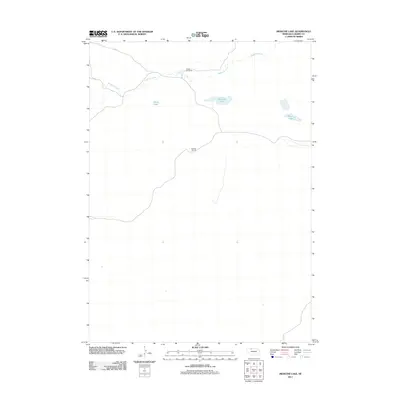
2011 Map of Medicine Lake
USGS Topo · Published 2011About this map
Broken Box Ranch and Rocking J Ranch define the sparse human footprint in this expansive portion of Cherry County. The landscape is characterized by the winding path of Medicine Creek, which feeds into a cluster of natural water bodies including Medicine Lake, Moon Lake, and the smaller Weed Lake. This part of the Nebraska Sandhills shows the enduring pattern of large-scale ranching and remote hydrology that has persisted for generations. Access to these isolated outposts is maintained by rugged routes like Eli Rd, which skirts the northern edge of the creek. The map reflects a region where the natural water table dictates the placement of settlements and the survival of cattle operations in a semi-arid environment.
Find a feature on this map
7 named features on this map. Tap any name to fly to it.
Don’t see what you’re looking for? This feature index may not catch every label — zoom into the map to look around manually.
Map Details
Editions of this 2011 Medicine Lake Map
This is the sole edition of this map. No revisions or reprints were ever made.
Other maps of this area

1950 · Doughboy
USGS Topo · 1:62,500

1951 · Merriman
USGS Topo · 1:62,500

1951 · Merriman 4
USGS Topo · 1:62,500

1952 · Eli
USGS Topo · 1:62,500

1952 · Doughboy
USGS Topo · 1:62,500

1957 · Valentine
USGS Topo · 1:250,000

1959 · Valentine
USGS Topo · 1:250,000

1985 · Heath Valley
USGS Topo · 1:24,000

1985 · Eli SE
USGS Topo · 1:24,000
1985 · Farm Flat
USGS Topo · 1:24,000