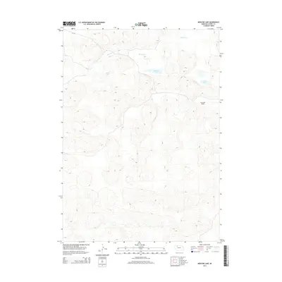
2014 Map of Medicine Lake
USGS Topo · Published 2014About this map
Medicine Lake and the surrounding Sandhills of Cherry County characterize this 2014 survey. The landscape is dominated by complex dune formations and a high water table, which feeds a cluster of small basins including Weed Lake and Moon Lake in the northeastern portion of the quadrangle. Medicine Cr winds through the northern hills, eventually feeding the larger lake that shares its name. The terrain is sparsely developed, with Eli Rd providing the primary access through the northern sector. This map provides a detailed view of the Cutcomb Valley, a distinct topographical feature that breaks the repetitive dune patterns. For those studying the hydrology of the Nebraska Sandhills, the proximity and elevation of these distinct water bodies offer a clear view of the region's unique wetland distribution at the start of the 21st century.
Find a feature on this map
6 named features on this map. Tap any name to fly to it.
Don’t see what you’re looking for? This feature index may not catch every label — zoom into the map to look around manually.
Map Details
Editions of this 2014 Medicine Lake Map
This is the sole edition of this map. No revisions or reprints were ever made.
Other maps of this area

1950 · Doughboy
USGS Topo · 1:62,500

1951 · Merriman
USGS Topo · 1:62,500

1951 · Merriman 4
USGS Topo · 1:62,500

1952 · Eli
USGS Topo · 1:62,500

1952 · Doughboy
USGS Topo · 1:62,500

1957 · Valentine
USGS Topo · 1:250,000

1959 · Valentine
USGS Topo · 1:250,000

1985 · Heath Valley
USGS Topo · 1:24,000

1985 · Eli SE
USGS Topo · 1:24,000
1985 · Farm Flat
USGS Topo · 1:24,000