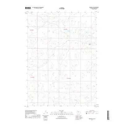
2017 Map of Medicine Lake
USGS Topo · Published 2017About this map
Medicine Lake and the winding Medicine Cr define this pocket of the Nebraska Sandhills, an area characterized by its unique interdunal wetlands and lakes. In this portion of Cherry County, water bodies such as Weed Lake, Gus Lake, and Moon Lake provide essential habitat and resources within the undulating terrain. The landscape is marked by the distinct Cutcomb Valley, which cuts through the sandy ridges. A single road, Eli Rd, serves as the primary corridor in the northwestern corner, reflecting the sparse settlement pattern and large-scale ranching operations typical of this region. The map preserves the specific hydrographic footprint of these lakes and creeks as they appeared in 2017, illustrating the delicate balance of water in an arid environment.
Find a feature on this map
11 named features on this map. Tap any name to fly to it.
Don’t see what you’re looking for? This feature index may not catch every label — zoom into the map to look around manually.
Map Details
Editions of this 2017 Medicine Lake Map
This is the sole edition of this map. No revisions or reprints were ever made.
Other maps of this area

1950 · Doughboy
USGS Topo · 1:62,500

1951 · Merriman
USGS Topo · 1:62,500

1951 · Merriman 4
USGS Topo · 1:62,500

1952 · Eli
USGS Topo · 1:62,500

1952 · Doughboy
USGS Topo · 1:62,500

1957 · Valentine
USGS Topo · 1:250,000

1959 · Valentine
USGS Topo · 1:250,000

1985 · Heath Valley
USGS Topo · 1:24,000

1985 · Eli SE
USGS Topo · 1:24,000
1985 · Farm Flat
USGS Topo · 1:24,000