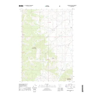
2020 Map of Medicine Lodge Peak
USGS Topo · Published 2020About this map
Beaverhead National Forest defines this high-elevation landscape in Beaverhead County, dominated by the prominent summits of Medicine Lodge Peak and Maiden Peak. The drainage patterns are intricate, with Medicine Lodge Creek flowing through the eastern terrain and numerous smaller tributaries like Hansen Creek and Schwartz Creek carving through deep canyons. Water sources are vital in this environment, evidenced by the presence of Keystone Reservoir, Lake Canyon Lake, and several named springs including Keystone Spring and the curiously named Shooting Herders Spring. The map documents a sparsely populated region accessible primarily via Schwartz Creek Rd and Medicine Lodge Rd, which navigate the steep topography between Ayers Canyon and Keystone Gulch. This 2020 survey provides an essential record of modern forest boundaries and hydrologic features for researchers monitoring the Montana wilderness.
Find a feature on this map
25 named features on this map. Tap any name to fly to it.
Don’t see what you’re looking for? This feature index may not catch every label — zoom into the map to look around manually.
Map Details
Editions of this 2020 Medicine Lodge Peak Map
This is the sole edition of this map. No revisions or reprints were ever made.
Other maps of this area

1955 · Dubois
USGS Topo · 1:250,000

1956 · Morrison Lake
USGS Topo · 1:62,500

1958 · Dubois
USGS Topo · 1:250,000
1965 · Garfield Canyon
USGS Topo · 1:24,000

1965 · Deadman Pass
USGS Topo · 1:24,000

1965 · Jeff Davis Peak
USGS Topo · 1:24,000
1965 · Hansen Ranch
USGS Topo · 1:24,000

1965 · Graphite Mountain
USGS Topo · 1:24,000

1965 · Deer Canyon
USGS Topo · 1:24,000
1965 · Medicine Lodge Peak
USGS Topo · 1:24,000