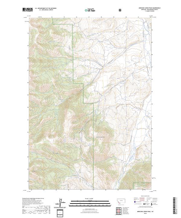
2024 Map of Medicine Lodge Peak
USGS Topo · Published 2024About this map
Medicine Lodge Peak commands the high ground of the Beaverhead National Forest in this high-altitude corner of southwest Montana. The drainage patterns of Medicine Lodge Creek and its various tributaries, including Schwartz Creek and Anton Creek, reveal a landscape shaped by seasonal hydrology and resource management. Small upland water sources, often vital for livestock and wildlife, are clearly marked through features such as Shooting Herders Spring, Ayers Canyon Spring, and Keystone Spring.
Find a feature on this map
26 named features on this map. Tap any name to fly to it.
Don’t see what you’re looking for? This feature index may not catch every label — zoom into the map to look around manually.
Map Details
Editions of this 2024 Medicine Lodge Peak Map
This is the sole edition of this map. No revisions or reprints were ever made.
Other maps of this area

1955 · Dubois
USGS Topo · 1:250,000

1956 · Morrison Lake
USGS Topo · 1:62,500

1958 · Dubois
USGS Topo · 1:250,000
1965 · Garfield Canyon
USGS Topo · 1:24,000

1965 · Deadman Pass
USGS Topo · 1:24,000

1965 · Jeff Davis Peak
USGS Topo · 1:24,000
1965 · Hansen Ranch
USGS Topo · 1:24,000

1965 · Graphite Mountain
USGS Topo · 1:24,000

1965 · Deer Canyon
USGS Topo · 1:24,000
1965 · Medicine Lodge Peak
USGS Topo · 1:24,000