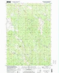
1998 Map of Medicine Mountain
USGS Topo · Published 2001About this map
Medicine Mountain stands as a prominent geographic anchor within the Black Hills National Forest, rising above a landscape defined by an intricate network of drainages and high-altitude prairies. This topography, based on data compiled in the mid-20th century and verified through the 1990s, reveals the scattered nature of human settlement in this part of Pennington County. The presence of the South Slate Sch and Medicine Mtn Ranch suggests a community oriented around ranching and rural education, while the small settlement of Tigerville sits near the confluence of Newton Fork. The map documents a rugged drainage system where Slate Creek and Spring Creek carve through the terrain, flanked by peaks such as Copper Mountain and Odakota Mountain. Local landmarks like Gillette Prairie and several named gulches, including Reno Gulch and Whitehorse Gulch, provide specific points of interest for those tracing the history of land use in the Black Hills.
Find a feature on this map
24 named features on this map. Tap any name to fly to it.
Don’t see what you’re looking for? This feature index may not catch every label — zoom into the map to look around manually.
Map Details
Editions of this 1998 Medicine Mountain Map
This is the sole edition of this map. No revisions or reprints were ever made.
Other maps of this area

1894 · Deadwood
USGS Topo · 1:125,000

1896 · Harney Peak
USGS Topo · 1:125,000

1901 · Harney Peak
USGS Topo · 1:125,000

1901 · Deadwood
USGS Topo · 1:125,000

1916 · Deadwood
USGS Topo · 1:125,000

1953 · Rapid City
USGS Topo · 1:250,000

1954 · Silver City
USGS Topo · 1:24,000

1954 · Custer
USGS Topo · 1:24,000

1954 · Hill City
USGS Topo · 1:24,000

1954 · Berne
USGS Topo · 1:24,000