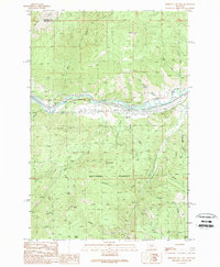
1989 Map of Medicine Tree Hill
USGS Topo · Published 1989About this map
Clark Fork carves through the mountain terrain of the Lolo National Forest in this late 1980s topographic study of the Montana high country. The river corridor serves as the primary artery for transportation and settlement, anchoring the small communities of Nimrod, Ravenna, and Bearmouth. This survey documents the landscape's relief through features like Mount Baldy and the namesake Medicine Tree Hill, while numerous drainages such as Harvey Gulch and Genoa Gulch cut deep into the timbered slopes. Evidence of land use is visible in the network of pipelines and the presence of a Borrow Pit near the river. For those researching the geography of the Missoula and Granite County line, the map detail provides a clear view of how water sources like Movie Spring and the Tyler Fork influenced the backcountry navigation of the era.
Find a feature on this map
32 named features on this map. Tap any name to fly to it.
Don’t see what you’re looking for? This feature index may not catch every label — zoom into the map to look around manually.
Map Details
Editions of this 1989 Medicine Tree Hill Map
This is the sole edition of this map. No revisions or reprints were ever made.
Other maps of this area

1903 · Bonner
USGS Topo · 1:125,000

1919 · Drummond
USGS Topo · 1:125,000

1921 · Drummond
USGS Topo · 1:125,000

1947 · Butte
USGS Topo · 1:250,000

1958 · Butte
USGS Topo · 1:250,000

1959 · Bearmouth
USGS Topo · 1:62,500

1959 · Ravenna
USGS Topo · 1:62,500

1960 · Butte
USGS Topo · 1:250,000

1962 · Butte
USGS Topo · 1:250,000

1965 · Union Peak
USGS Topo · 1:24,000