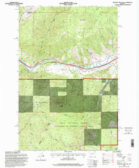
1996 Map of Medicine Tree Hill
USGS Topo · Published 1998About this map
The Clark Fork river valley serves as the primary corridor through this mountainous section of western Montana, cutting between the peaks of the Lolo National Forest. This 1990s survey captures the region's complex administrative and industrial landscape, where the forest is noted as being administered by Deerlodge National Forest south of the river. Small settlements and transit points like Nimrod and Bearmouth are situated along the valley floor, positioned near the river and the prominent Medicine Tree Hill.
Find a feature on this map
31 named features on this map. Tap any name to fly to it.
Don’t see what you’re looking for? This feature index may not catch every label — zoom into the map to look around manually.
Map Details
Editions of this 1996 Medicine Tree Hill Map
This is the sole edition of this map. No revisions or reprints were ever made.
Other maps of this area

1903 · Bonner
USGS Topo · 1:125,000

1919 · Drummond
USGS Topo · 1:125,000

1921 · Drummond
USGS Topo · 1:125,000

1947 · Butte
USGS Topo · 1:250,000

1958 · Butte
USGS Topo · 1:250,000

1959 · Bearmouth
USGS Topo · 1:62,500

1959 · Ravenna
USGS Topo · 1:62,500

1960 · Butte
USGS Topo · 1:250,000

1962 · Butte
USGS Topo · 1:250,000

1965 · Union Peak
USGS Topo · 1:24,000