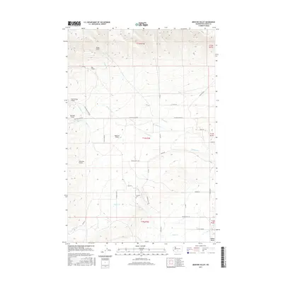
2017 Map of Medicine Valley
USGS Topo · Published 2017About this map
Medicine Valley and the surrounding Yakima County landscape are defined by a complex network of canyons and drainage systems feeding into the Simcoe Cr basin. The area exhibits a distinct transition from the high, dissected terrain of Poison Canyon and Hog Canyon in the north to the lower valley floor near White Swan. This 2017 survey details the cultural landscape of the Yakama Reservation, centered on the Agency and the Yesmowit Cem. The irrigation and agricultural development of the valley are traced through features like N Canal Rd and various Bureau of Indian Affairs (BIA) routes. Water management is central to the valley's layout, with N Medicine Cr and S Medicine Cr converging as they flow toward the settlement at White Swan. Numerous named canyons, including Old Maid Canyon and Whitefoot Canyon, underscore the geographic diversity of this interior basin.
Find a feature on this map
48 named features on this map. Tap any name to fly to it.
Don’t see what you’re looking for? This feature index may not catch every label — zoom into the map to look around manually.
Map Details
Editions of this 2017 Medicine Valley Map
This is the sole edition of this map. No revisions or reprints were ever made.
Other maps of this area

1899 · Ellensburg
USGS Topo · 1:125,000

1901 · Ellensburg
USGS Topo · 1:125,000

1937 · White Swan
USGS Topo · 1:125,000

1950 · Yakima
USGS Topo · 1:250,000

1957 · Yesmowit Canyon
USGS Topo · 1:24,000
1957 · Willy Dick Canyon
USGS Topo · 1:24,000

1958 · Toppenish Mtn.
USGS Topo · 1:24,000

1958 · Fort Simcoe
USGS Topo · 1:24,000

1958 · Fort Simcoe
USGS Topo · 1:62,500

1958 · Wiley City
USGS Topo · 1:24,000