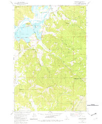
1981 Map of Medimont
USGS Topo · Published 1982About this map
The Coeur d'Alene River winds through a complex landscape of wetlands and timbered peaks in this early 1980s study of the Idaho panhandle. The settlement of Medimont serves as a central point for local activity, situated near the Medimont Cemetery and the Rainy Hill Picnic Area. This era shows a clear intersection of industrial extraction and natural preservation, as the Union Pacific railroad tracks skirt the edges of Medicine Lake, Swan Lake, and Cave Lake. The map illustrates the region's topographical transition from the river valley to prominent heights like Initial Peak and Medicine Mountain. Resource extraction is evident through several sites, including a Quarry, multiple gravel pits, and the New Rainbow Mine located along Smith Ridge. The Coeur d'Alene Indian Reservation Boundary bisects the southern half of the quadrangle, reflecting the complex land management of the Idaho interior.
Find a feature on this map
43 named features on this map. Tap any name to fly to it.
Don’t see what you’re looking for? This feature index may not catch every label — zoom into the map to look around manually.
Map Details
Editions of this 1981 Medimont Map
This is the sole edition of this map. No revisions or reprints were ever made.
Other maps of this area

1903 · Rathdrum
USGS Topo · 1:125,000

1909 · Cataldo
USGS Topo · 1:125,000

1911 · Cataldo
USGS Topo · 1:125,000

1950 · Rochat Peak
USGS Topo · 1:24,000

1952 · Rochat Peak
USGS Topo · 1:24,000

1955 · Spokane
USGS Topo · 1:250,000

1957 · St. Maries
USGS Topo · 1:62,500

1957 · Kingston
USGS Topo · 1:62,500

1957 · Lane
USGS Topo · 1:62,500

1957 · St. Joe
USGS Topo · 1:62,500