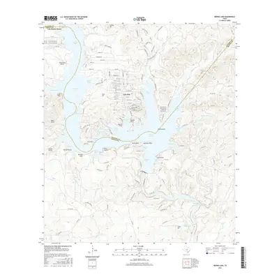
2016 Map of Medina Lake
USGS Topo · Published 2016About this map
Medina Lake serves as the focal point for this area along the Bandera and Medina county line, where complex shoreline developments like Lake Hills and Lake Medina Shores meet the limestone bluffs of the Texas Hill Country. The intricate geometry of the reservoir is defined by numerous named inlets including Spettel Cove, Sawmill Cove, and Plum Creek Cove, while local landmarks like Mormon Bluff and Devils Bluff rise above the water's edge. This 2016 survey illustrates a modern landscape of dense residential street grids carved into the terrain, particularly around Lake Hills, contrasted with the winding courses of Mexican Cr and Koenig Cr to the south. Notable features such as Walton Island and Diversion Lake highlight the managed hydrology of the river system, while historical place names like Devils Kitchen and Polecat Hollow persist alongside contemporary subdivisions.
Find a feature on this map
155 named features on this map. Tap any name to fly to it.
Don’t see what you’re looking for? This feature index may not catch every label — zoom into the map to look around manually.
Map Details
Editions of this 2016 Medina Lake Map
This is the sole edition of this map. No revisions or reprints were ever made.
Other maps of this area

1954 · San Antonio
USGS Topo · 1:250,000

1956 · New Fountain
USGS Topo · 1:62,500

1956 · Bandera
USGS Topo · 1:62,500

1956 · Medina Lake
USGS Topo · 1:62,500

1957 · San Antonio
USGS Topo · 1:250,000

1958 · La Coste NE
USGS Topo · 1:24,000

1964 · Riomedina
USGS Topo · 1:24,000

1964 · Bandera
USGS Topo · 1:24,000

1964 · Timber Creek
USGS Topo · 1:24,000

1964 · Medina Lake
USGS Topo · 1:24,000