
1964 Map of Bandera
USGS Topo · Published 1967About this map
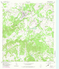
Bandera sits at a sharp bend in the Medina River, serving as the central hub of this mid-1960s Hill Country landscape. The town's layout is clearly defined, featuring local institutions like St Joseph Sch and a municipal Sewage Disposal plant. Just outside the main residential blocks, a Drive-in Theater and a nearby Landing Strip reflect the era's mid-century automotive and aviation infrastructure. To the north, Lake Hiawatha and Mud Creek provide recreational and water resources, while the terrain rises sharply to the southwest toward Town Mountain and Potato Flats.
Find a feature on this map
42 named features on this map. Tap any name to fly to it.
Don’t see what you’re looking for? This feature index may not catch every label — zoom into the map to look around manually.
Map Details
Editions of this 1964 Bandera Map
2 editions found
Other maps of this area

1954 · San Antonio
USGS Topo · 1:250,000

1956 · Comfort
USGS Topo · 1:62,500

1956 · Bandera
USGS Topo · 1:62,500

1956 · Medina Lake
USGS Topo · 1:62,500

1956 · Center Point
USGS Topo · 1:62,500

1957 · San Antonio
USGS Topo · 1:250,000

1964 · Timber Creek
USGS Topo · 1:24,000

1964 · Rock Cliff Reservoir
USGS Topo · 1:24,000

1964 · Medina Lake
USGS Topo · 1:24,000
1964 · Turkey Knob
USGS Topo · 1:24,000