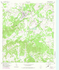
1964 Map of Bandera
USGS Topo · Published 1983About this map
Bandera sits at the heart of this mid-century survey, tucked into a sharp bend of the Medina River. The town layout shows a concentrated grid surrounded by the winding waters of Mad Doe Creek and the southern edge of Lake Hiawatha. To the south and west, the landscape shifts dramatically into the high relief of the Texas Hill Country, characterized by family-named landmarks like Kindla Spring and topographic heights such as Town Mountain. The presence of the Flying L Ranch Airport and a nearby Golf Course northeast of the river reflect the area's development into a regional recreation and ranching destination during the 1960s. Rural infrastructure, including numerous Gravel Pits and cattle-related terrain markers like Potato Flats and Gate Hollow, provides a clear view of the working landscape outside the central settlement. Significant water sources such as Mansfield Spring and San Julian Creek further define the geography of the outlying ranch lands.
Find a feature on this map
48 named features on this map. Tap any name to fly to it.
Don’t see what you’re looking for? This feature index may not catch every label — zoom into the map to look around manually.
Map Details
Editions of this 1964 Bandera Map
2 editions found
Other maps of this area

1954 · San Antonio
USGS Topo · 1:250,000

1956 · Comfort
USGS Topo · 1:62,500

1956 · Bandera
USGS Topo · 1:62,500

1956 · Medina Lake
USGS Topo · 1:62,500

1956 · Center Point
USGS Topo · 1:62,500

1957 · San Antonio
USGS Topo · 1:250,000

1964 · Bandera
USGS Topo · 1:24,000

1964 · Timber Creek
USGS Topo · 1:24,000

1964 · Rock Cliff Reservoir
USGS Topo · 1:24,000

1964 · Medina Lake
USGS Topo · 1:24,000