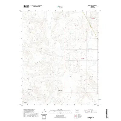
2020 Map of Medina Mesa
USGS Topo · Published 2020About this map
Medina Mesa dominates the high ground of San Miguel County in this modern survey, where the rugged plateau surface breaks away into deep drainages like Medina Canyon and Monia Canyon. The landscape is defined by its arid hydrology, showing an extensive network of water catchments essential for ranching in this part of New Mexico. Named features like Tanque Grande, Blue Tank Number One, and Blue Tank Number Two reveal the placement of vital infrastructure across the high desert terrain. Along the southern edge of the quadrangle, landmarks such as Miller Peak and Gobblers Knob provide distinct elevation markers. The map also records the boundary line where Harding Co meets San Miguel Co, intersected by seasonal drainages including Wynn Cr and Atarque Cr.
Find a feature on this map
25 named features on this map. Tap any name to fly to it.
Don’t see what you’re looking for? This feature index may not catch every label — zoom into the map to look around manually.
Map Details
Editions of this 2020 Medina Mesa Map
This is the sole edition of this map. No revisions or reprints were ever made.
Other maps of this area

1930 · Tucumcari
USGS Topo · 1:125,000

1954 · Tucumcari
USGS Topo · 1:250,000

1958 · Tucumcari
USGS Topo · 1:250,000

1967 · Trinchera Creek
USGS Topo · 1:24,000

1968 · Bascom Camp
USGS Topo · 1:24,000

1968 · Hampton Ranch
USGS Topo · 1:24,000

1968 · Carpenter Mesa SW
USGS Topo · 1:24,000

1968 · Carpenter Mesa NW
USGS Topo · 1:24,000
1968 · Medina Mesa
USGS Topo · 1:24,000

1969 · Gallegos
USGS Topo · 1:24,000